Yesterday we travelled to join them on the boat.
This post is quite long, so if you just want to view the photos follow this link.
The map below shows the location of the Marina (the place mark at the top). The map can be operated like a normal Google Map, but it is probably better to click on the View Larger Map link at the bottom. If you choose the Satellite option and zoom in as far as possible the place mark is pointing at the Manera.
View Larger Map
 | We arrived after dark, boarded, and walked down the fore deck shown in the photo.
|
Thursday morning dawned bright and fine ...

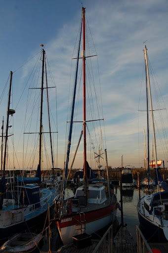 | ... giving us a clearer view of the boat. |
Unfortunately, I didn't take many pictures of the interior, but the photos on this link clearly show that there is plenty of room down below, in a Swanson 42.
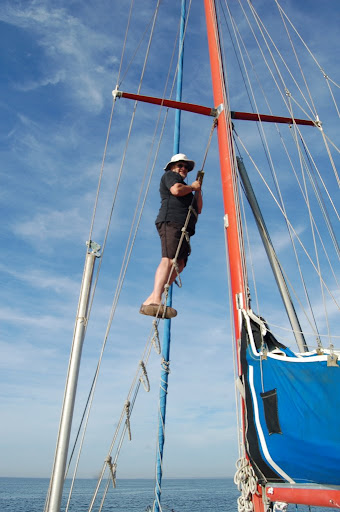
| After checking over the boat, which included the rigging as can be seen in the photograph, David and Glenda manoeuvred the yacht from its tight berth into the main channel of the marina. This required some magic with ropes and at the helm.
|  |
With Glenda at the helm we gently motored out of the marina. Westernport is very tidal, and we could only access the deeper water via channels. Sailing times are not determined by the whim of the captain, but by the requirements of the tide. We left at 9:20 am to ensure that our boat, with a draft of 1.8 metres could negotiate the two shallow places in the channel. David and Glenda discovered this once when sailing, getting firmly stuck on one of the shallow places. Although they spent a worrying couple of hours, they learned important information about the characteristics of the Manera on that occasion. The tide was still receding when they stuck fast, and after a while the boat rapidly tilted over to a 45 degree angle. Some boats do not recover well from such a predicament, but happily as the tide started rising, some hours later, the boat quickly righted itself.
When we finally cleared the channel, after about one nautical mile, David and his friend Jim, raised the sails. The Manera has a cutter rig, meaning that it has one mast, a mainsail, and can have two headsails set. We sailed with only the mainsail and one headsail.
I will try to use technical, nautical terms so the diagram below might be of help in deciphering my descriptions.
 | 1 main sail |
Another useful reference is this Wikipedia article.
The mainsail is raised using a rope called the main halyard.
The headsail is furled (wound) around the forestay, which is a piece of standing rigging which keeps a mast from falling backwards. It is attached to the top of the mast, at one end and to the bow of the boat at the other.
Before we left the marina, David had attached two ropes, called the headsail sheets, to the free corner of the headsail, the clew. These sheets were run through pulleys back to the cockpit, where the helm is located. David pulled the leeward sheet using a winch to set the headsail into position.
For a while the wind was too light for the sails to provide forward motion, though the water though the tide was moving us, slowly, in reference to the bottom of the bay. After a few minutes Glenda gave over the helm to Jim, a friend who lives on his boat at the marina. Jim is an experienced sailor, having participated in the >Sydney-Hobart race.
David and Glenda have also has experience in blue water sailing. They purchased the Manera in Brisbane and sailed the boat back to Victoria, with the help of Jim and a few other friends. They have also sailed her to from Western Port to Wilson's Promontory.
After Jim had sailed the boat for a while I took over the helm. This task is not quite as easy as it seems, as there are a range of issues to be considered.
An appropriate heading has to be determined. It is not always possible to go directly to the destination - the wind might be blowing from an inappropriate quarter, and shallow water has to be avoided. One method of keeping on the chosen heading is to pick out a landmark in the right direction and sail towards it. There are also instruments available to assist in maintaining the heading. The Manera has three of them, the compass at the helm, and electronic compass as shown at left in the photo below ...

... and the chart plotter, below.

The chart plotter provides a great deal of information. The black oval shape near the bottom of the screen is the location of the boat. The heading can be seen (on the right) as 357 degrees (this photograph was taken while we were returning to the marina). The green line shows the heading graphically and the blue line with arrow is the direction of the tide. The boat's speed of 7.4 nautical miles is a combination of speed through water and the tide. The white areas signify deeper water, the shallow blue areas should be avoided.
The depth of the water can be monitored in two ways. The first is via the depth meter next to the electronic compass the second is by using the chart plotter.
The third issue to be monitored was brought home to me when Jim cautioned me to watch the wind direction which was heading around aft, and which could cause an unintentional gybe. The definition of a gybe (or jibe) below is taken from this site.
A jibe or gybe is a sailing maneuver where a sailing vessel turns its stern through the wind, such that the wind direction changes from one side of the boat to the other. ... In this maneuver the mainsail will cross the center of the boat while the jib (foresail) is pulled to the other side of the boat.
As a result of Jim's comment I adjusted the heading a little to port (the left). An instrument is available to determine the direction of the wind, relative to the boat. It is shown to the right of the clock in the photo below.

The photograph was taken on our return trip, when we were using the motor rather than the sails. At the time of the photograph, the wind was coming from about 15 degrees to starboard. When I took over the helm the ideal direction of the wind was 120 degrees on the port side. After Jim's warning I carefully watched the wind direction.
As well as heading, depth of water and wind direction, the person at the helm must regularly scan the water for other vessels.
About 10 or 15 minutes after I took over the helm we started to approach the shallower water (as indicated by the chart plotter) and a change of heading was required. As we were reaching, in fact close to a broad reach, the appropriate manoeuvre was a gybe (described above).
Jim adjusted the main sheet to make sure that the boom did not come across too fast. Then David loosened the starboard headsail sheet (from the winch) and after I turned the helm to starboard, Jim pulled in the port headsail sheet, until the sail was positioned and drawing air on the port side. While all of this was going on, the main automatically changed from starboard to port.
We sailed for a while toward Lysart's pier and then gybed back to port.
We then sailed on passing French Island to port and the Mornington Peninsula to starboard, with me at the helm ...

and, Frankie ...

... Glenda ...

... Margaret ...

... Jim ...

... and David ...

... chilling.
A mile of so east of Cowes, on Philip Island, we noticed one of the Bass Straight oil platforms moored near the shore. A few hundred metres off Cowes we decided that we had travelled far enough to the south and decided to turn start our return to the marina. This time the appropriate turn was a tack. This involves turning the boat through the wind. It is important to have plenty of speed before performing a tack, as part of the way through the procedure, the boat looses power as it is pointing directly into the wind.
I turned the helm hard to starboard, and David and Jim started to move the headsail from port to starboard. Just after we had passed the half way point, they held the headsail in only part of the way across to get wind into it as quickly as possible so we could complete the turn as quickly. Then they secured the sail to its new position on the port side. Naturally the mainsail moved across automatically.
We took a heading reasonably close to the wind (close hauled), with the sails trimmed in fairly tightly. This was to avoid excessive rolling as Glenda was below preparing lunch - hot crossed buns and watermelon.
While we were sailing between Mornington Peninsula and French Island, we heard a radio communication with the ship Iron Monarch. Looking around we could see the ship a couple of miles aft. It was travelling much faster than we were and relatively soon it caught up to us and passed us. We kept out of its way, which was fairly easy as it had to stay in the channel.
Soon after we noticed that we were on a potential collision course with a trimaran. We watched the boat closely. We had the right of way as we were on starboard tack and he was on port tack, but not all sailors take notice of the rules. Happily the trimaran sailor did know the rules as he changed direction to pass aft of us.
The wind was coming from the direction we needed to go, so we were sailing close hauled, close to the wind, but not making much headway as the wind was dying. Consequently, we took down the sails and started motoring. There are not many landmarks in the northern section of Westernport, which would make for difficulties in finding the channel to the marina, if it were not for the fact that it was clearly marked on the chart plotter.
I was still at the helm, when David and Jim started a conversation about araldite. I suspected that it was about me, which was confirmed when they explained that someone who does not easily give up the helm is called Captain Alaldite. This has become my nickname according to David.
Six hours after leaving we arrived back at the marina. After a peaceful few hours on deck, a pleasant dinner, Margaret and I headed home into the sunset ...

... while Glenda and David stayed another couple of days on the yacht.
2 comments:
For a land lubber who has not sailed much an interesting blog
JOHN K
Captain Alaldite, looks like you have found your calling! Didn't realise how complicated sailing was.
Suzanne
Post a Comment